Based on active installations per country, sourced from the WPoptic database.
856 results available. Download your leadlist
Yes, users can download comprehensive lead lists including domain names, contact information, and additional metadata. This feature requires an account, check out our lead list page where you can create an account and get 50 credits for free!
WPoptic does the hard work for you. You can use our leadlists, websitescanner or our free browser extension.
WPoptic uses multiple detection methods including HTTP headers, HTML source analysis, JavaScript fingerprinting, and CSS pattern recognition to identify WordPress plugins across millions of websites.
Contact our team for custom requests, information or enterprise solutions.
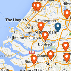
Access a Curated Database of 856 MapGeo – Interactive Geo Maps Websites
Leverage a Curated Database of 856 websites using the MapGeo – Interactive Geo Maps WordPress plugin.
Access detailed analytics, download lead lists, and discover trends across 17,000+ WordPress plugins